
Use case · Fixed wireless access
Qualify fixed wireless access on line-of-sight, from your desk
Fixed wireless access lives or dies on one question: is the path from tower to rooftop actually clear? rfMAP answers it on the desk, with sub-meter 3D buildings and vegetation heights, so the line-of-sight and Fresnel check happens before anyone schedules a truck.
Get a demo →The decision
Can we serve this address over the air?
Fixed wireless access promises broadband without trenching: a radio on a tower, a receiver on a rooftop, and a clear path between them. The whole business case rests on that path. If a tree line or a single building edge cuts the line of sight, the link degrades or fails, and the install becomes a wasted truck roll.
So before you quote a household or a campus, you have to answer one thing honestly: is the path from the serving cell to that rooftop actually clear, and does it stay clear through the zone the signal needs? On 2D maps you cannot. Street centerlines do not carry rooftop heights, tree heights, or what stands between the two.
What the check resolves
Line of sight, and the zone around it
Is the path unobstructed?
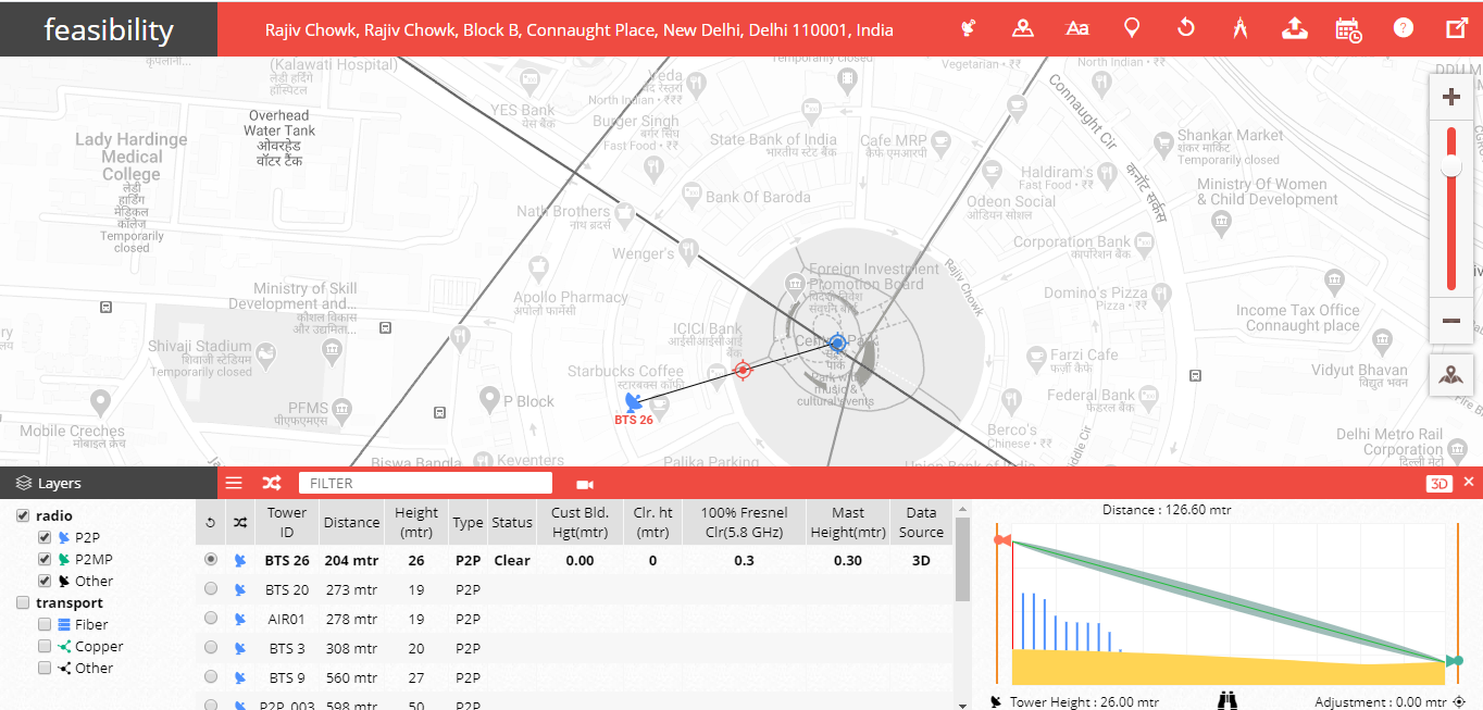
The direct path between transmitter and receiver, checked against 3D buildings and 3D vegetation heights rather than a flat plan view.
Does the clearance hold?
The ellipsoid around the line-of-sight path that must stay clear for signal quality, evaluated against the same 3D surface, not just the centerline.
What is the path crossing?
Land-use classification, up to 35 clutter classes, so the link budget reflects vegetation, built-up areas and open ground along the route.
Where does the receiver sit?
Rooftop and structure heights from sub-meter 3D buildings, so the candidate mount point is real geometry, not an assumption.
Why 2D quietly fails FWA
5G cells reach roughly 300 to 500 meters and die on line of sight. At those ranges a rooftop parapet, a mature tree, or one taller neighbor decides whether the link closes. None of that exists on a 2D map of street centerlines.
rfMAP carries the geometry that decides it: 3D buildings with footprints and rooftops, 3D vegetation with height attributes, terrain as DTM and surface as DSM. The path check runs against the world as it actually stands.
The path either clears, or it does not. On 3D, you know before the truck.
Line of sight and the Fresnel zone resolve against sub-meter buildings and vegetation heights, so a candidate rooftop is qualified or ruled out at the desk, before anyone is dispatched.
How rfMAP answers it
A desk check against real geometry
rfMAP supplies the authentic 3D geodata the check needs: 3D buildings with footprints and rooftops, 3D vegetation in stacked polygons with height attributes, 4D bridges, DTM, DSM/Clutter Height and 2D vectors, with land-use clutter classified into up to 35 classes, all at sub-meter precision. That data feeds the neo360 5G FWA planning module, which runs the line-of-sight and Fresnel-zone analysis on top of it. The qualification that used to wait on a physical survey becomes a query you run from your desk.
What qualifying on the desk changes
- 01
Fewer wasted truck rolls
Candidates with a blocked path or a marginal Fresnel zone are ruled out before dispatch, so crews visit addresses that are likely to close.
- 02
Honest serviceability footprints
A coverage map built on 3D line-of-sight reflects what the radio can actually reach, not an optimistic 2D circle.
- 03
One dataset, every RF tool
The same vendor-neutral 3D layers feed neo360 and the RF planning, drive-test and GIS tools your team already runs.
The survey objection
"We will just survey it"
Physical site surveys are exactly the cost rfMAP is built to remove. When the line-of-sight and Fresnel check runs on sub-meter 3D data at the desk, the survey stops being the way you qualify every candidate and becomes the exception you reserve for the genuinely ambiguous ones. Fewer site visits, the same confidence in the path.
Proof
The 3D data behind India's 5G
The same authentic 3D geodata that powers line-of-sight and Fresnel planning carries more than 95% of India's 5G deployment through the Lepton 3D dataset, across a footprint mapped over 128 countries and 3150 cities. The geometry that qualifies a single FWA rooftop is the geometry trusted at national scale.
- Airtel
- Reliance Jio
- Vodafone Idea
- Ericsson
- Nokia
- American Tower
Qualify your FWA footprint on 3D, before the truck rolls.
Bring a candidate address list. We will show you how line-of-sight and Fresnel-zone checks run on rfMAP 3D data, paired with the neo360 5G FWA module.
Get a demo →