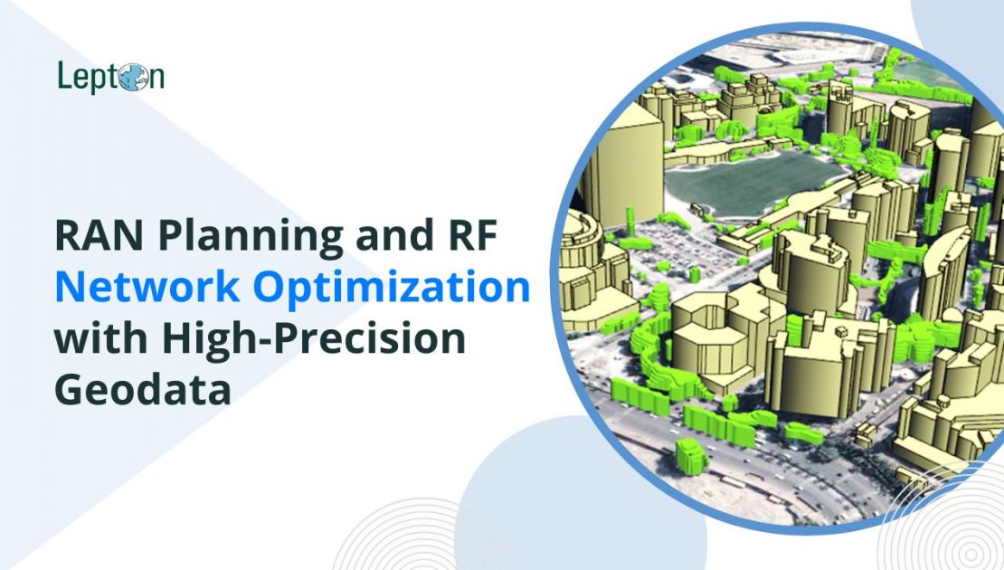
rfMap – RAN Map is a product by Lepton Software, a leader in geodata for wireless network planning and optimization used extensively in the telecom industry. Our USP lies in developing high-precision RF geodata over multiple formats like 3D Maps, 2.5D Maps, and 2D Maps — with layers including Clutter, DTM, DSM, building footprints with height, and a wide range of map-based datasets tailored for RAN planning and optimization.
RF Network Planning and Optimization with Geospatial Intelligence
In an era of rapid 5G deployments and increasing demand for seamless wireless connectivity, Radio Access Network (RAN) planning is more critical than ever. The major goal is to help telecom operators accurately analyze and deploy their networks by using high-quality rfMap geodata, enabling faster, more cost-effective, and highly reliable network rollout and optimization.
Using a digital RF map to plan your radio frequency coverage ensures that every subscriber gets reliable access to your network within the target area. Lepton provides a comprehensive set of geospatial datasets that form the foundation of successful RAN design and ongoing RF optimization.
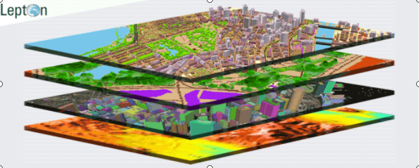
Geodata Layers That Power Accurate RF Planning
To help you plan your RF network with maximum precision, we offer the following data assets within our rfMap toolkit:
DTM (Digital Terrain Model)
A topographic representation of the bare earth surface, used to model elevation changes that can affect signal propagation.
Clutter Data
Contains information about surface types — urban, suburban, vegetation, water bodies, and more. Helps estimate population density, optimize signal reach, and minimize interference across different terrain types.
Road Vectors
Includes road, rail, metro, and waterway networks. Telecom operators utilize this to ensure seamless network coverage along transit routes, especially for mobile broadband and smart city deployments.
Population Map
Models population distribution and growth projections based on local census and settlement data. Helps in planning base station placement to ensure optimal signal distribution and network capacity management.
3D Map Dataset (1m Resolution)
Accurate raster and vector-based 3D maps with detailed elevation for buildings, trees, and urban features — crucial for line-of-sight analysis, capacity planning, and 5G mmWave deployment.
What is RAN Planning?
Radio Access Network planning involves proposing optimal locations, configurations, and technical parameters for new wireless network nodes. RAN planning is foundational to telecom expansion strategies and includes:
- Achieving optimal coverage across targeted geographies.
- Minimizing signal interference and achieving low bit-error rates.
- Ensuring capacity readiness with minimal service blocking and high user throughput.
- Reducing dropped call rates while maximizing user experience.
- Minimizing infrastructure costs through efficient use of transmitters, towers, and base stations.
Why Geodata is the Backbone of Wireless Network Planning
Whether you’re designing an LTE network, densifying 4G infrastructure, or rolling out 5G small cells, geospatial data is critical. High-resolution RAN maps, when integrated with planning tools, provide the actionable insights required for:
- Accurate signal modeling and propagation
- Interference analysis
- Line-of-sight visibility
- Capacity distribution based on real-world population data
- Strategic site selection for towers and equipment
A Case study on Fixed Wireless Access:
5G fixed wireless access (FWA)
FWA is likely to be the earliest 5G use case. In FWA, an indoor customer premise equipment (CPE) will receive the signal from an outdoor macro cell and then retransmit to indoor users. In order to obtain optimal received signals from outdoor macro cells, the location where the CPE will be installed needs to be carefully considered. With advanced Radio Planning tools like and RF Analysis in 3D using data having joint outdoor indoor modelling capability, the good signal coverage regions for CPE locations are clearly identified, which help to ensure excellent indoor communications quality and to reduce the manual work of testing. Furthermore, given the candidate locations in coverage regions of good signal quality, the optimal CPE location can be obtained using optimization modules.
Lepton Software: Powering Smarter RAN Planning
Lepton’s rfMap platform is trusted by telecom giants for RAN optimization, spectrum planning, and advanced 5G rollouts. Our geodata is engineered to integrate with major planning tools, accelerate feasibility studies, and help reduce CAPEX and OPEX.
Whether you are an operator, systems integrator, or network engineering partner, Lepton’s geospatial datasets deliver the intelligence you need to plan smarter and scale faster.
