
Maps are one of the most effective ways to visualize and present information. Traditionally, mapping has been done manually, needing a steady hand, full attention, and a lot of patience.
Fast-forward to now, we use Geographic Information System or GIS to produce detailed maps in a matter of minutes. GIS mapping has radically altered how information about our surroundings is applied and shared. It’s hard to imagine our lives without GIS mapping software, especially since a study shows that over 77% of smartphone users regularly rely on navigation maps to get around.
While GIS helps us with navigation and finding good restaurants nearby, its mapping function is what has truly changed how we analyze data. GIS mapping takes geographical information and turns it into digital maps, making it easier to spot patterns, trends, and connections. This has had a significant impact on various industries, including urban planning, environmental analysis, and asset management, which rely on geographical data.
The global GIS market is expected to reach $35.2 billion by 2025. The transportation sector is the largest user of GIS technology, followed by the utilities sector, the government sector, and the manufacturing sector.
GIS technology is used by businesses in a variety of applications, including:
- Supply chain management
- Customer relationship management
- Risk assessment
- Marketing
- Asset management
- Environmental monitoring
- Disaster management
The use of GIS technology by businesses is growing rapidly, due to the increasing availability of data and the decreasing cost of technology.
As you can see, GIS technology is a powerful tool that can be used by businesses in a variety of ways. The use of GIS technology by businesses is growing rapidly, and it is likely to become even more important in the future.
What is GIS Mapping?
GIS mapping, also known as Geographic Information System mapping, is a technology that allows us to visualize, analyze, and interpret data based on its geographic location. It combines geographical data with attribute data (such as population, land use, or temperature) to create interactive and dynamic maps. GIS mapping enables us to understand spatial relationships, patterns, and trends, providing valuable insights for various applications and industries.
With GIS mapping and knowing how to use GIS mapping software, we can overlay different layers of information onto a map, allowing us to see how different factors interact with each other in a specific geographic area. It is commonly used in fields like urban planning, environmental monitoring, agriculture, transportation, disaster management, and more.
Types of GIS Mapping
Based on what needs to be visualized, a variety of GIS maps can be used. From population density to 3D building details, everything can be visualized on these maps using robust GIS mapping software.
Let’s understand these types:
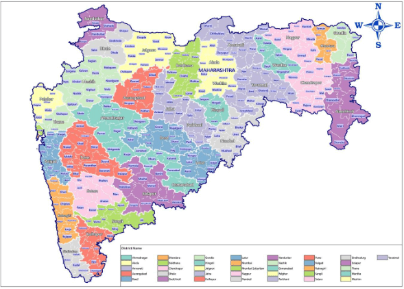
Category Maps
Category Maps are the most common type of GIS maps since they are the easiest to create. A specific data point or attribute is presented with a distinct color. The result is a detailed map with a variety of colors depicting multiple data points
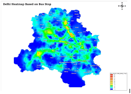
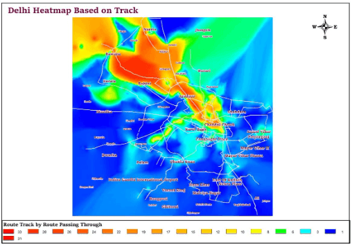
Heat Maps
Heat maps are generally used when the data you want to represent is complex and confusing, and a general idea of “warmer” and “colder” regions can help. Here, red stands for heat, and blue stands for cold. It can give a rough picture of quantity distribution.
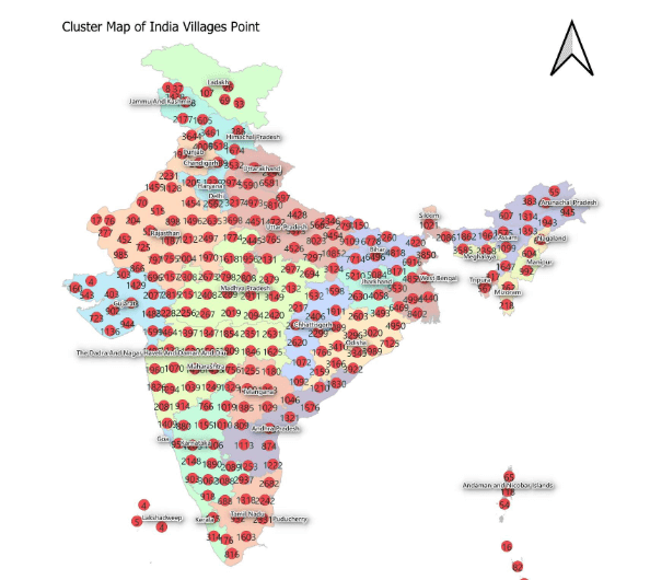
Cluster Maps
As the name suggests, these maps combine colors and shapes to cluster densely packed data points together.
Quantity Maps
A GIS quantity map is color-coded but it uses different shades of the same color palette to represent different quantities of something depicted on the map.
What is GIS Mapping Software?
GIS mapping software provides the platform for users to merge their data with geography and create immersive and dynamic maps having the ability to impact crucial business decisions.
Here are some of the key reasons why GIS mapping software is necessary:
Spatial analysis: GIS software enables users to conduct complex spatial analysis and modeling. It can help answer questions related to proximity, spatial patterns, and relationships between different geographic features. This is particularly useful in urban planning, environmental studies, and resource management.
Data visualization: GIS mapping software allows users to represent data visually on maps, which makes it easier to understand and interpret information. By displaying data in a geographic context, patterns and trends become more apparent.
Decision-making support: GIS software helps in making informed decisions by providing a spatial perspective on various issues. Whether it’s determining the best location for a new facility, assessing the impact of a natural disaster, or planning transportation routes, GIS aids in better decision-making.
Resource management: Governments, businesses, and organizations use GIS software to manage and optimize resources effectively. This includes managing land use, water resources, wildlife habitats, and agricultural areas.
Emergency response and disaster management: During emergencies and natural disasters, GIS mapping software becomes invaluable in coordinating response efforts, assessing damages, and identifying vulnerable areas that need assistance.
Environmental monitoring: GIS software assists in monitoring changes in the environment, such as deforestation, urban sprawl, and climate patterns. It helps scientists and researchers understand environmental issues and design appropriate conservation strategies.
Infrastructure planning: For urban and regional planning, GIS software helps in designing and maintaining infrastructure like roads, utilities, and public services. It ensures efficient use of space and resources.
Market analysis and business intelligence: In the business world, GIS software aids in market analysis by visualizing customer data, identifying target areas, and optimizing sales territories. It helps businesses make data-driven decisions and understand their customer base better.
Historical analysis and documentation: GIS software is also used in historical research to analyze historical maps, identify changes over time, and document historical events or land use patterns.
Public engagement and transparency: By visualizing data on maps, mapping software facilitates public understanding of complex issues, encourages transparency in decision-making processes, and promotes community engagement in various projects.
5 Components every GIS Mapping Software has:
- GIS Hardware: Hardware refers to the physical equipment that supports an organization’s GIS journey. For example, a desktop, handheld equipment used in-field GIS surveys and operations, web servers and cloud services used to carry out GIS projects.
- GIS Software: There are a range of Geo mapping software that helps to store, organize, manage, and transform spatial data into data-driven insights. These include
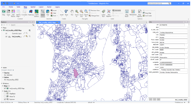
- Desktop GIS: An all-inclusive desktop mapping solution designed for GIS analysts, allowing them to visualize, analyze, edit, interpret, and generate data output. A great example of this software would be MapInfo Pro by Precisely–best
Web GIS: Cloud-based GIS mapping software to manage spatial data.
GIS Data: Spatial data such as vector and raster data is the fuel to all GIS software.
GIS Methods: A well-designed process to ensure an organization achieves all it’s GIS-related goals.
Users: They are the GIS professionals working on the platform acting as a catalyst for maximizing the potential of geographical mapping software.
How to choose the best GIS mapping software for your business?
Choosing the right mapping software can be crucial for your specific needs. Here are some key factors to consider when selecting mapping software:
Functionality and Features: Determine the specific features and functionalities you require. Some software may focus on basic mapping and visualization, while others offer advanced spatial analysis, 3D mapping, or specialized tools for particular industries (e.g., urban planning, ecology, logistics).
User-Friendliness: Consider the ease of use and user experience of the GIS software. Look for software that has an intuitive interface and provides a smooth learning curve, especially if you and your team are not GIS experts.
Data Compatibility: Check if the software supports the types of data you work with (e.g., shapefiles, GeoTIFFs, GPS data). Ensure it can handle your data formats and sources.
Data Sources and Updates: Consider if the software provides access to relevant data sources like satellite imagery, aerial photos, or real-time data. Regular updates and access to the latest information can be crucial for accurate analysis.
Scalability and Performance: Assess the GIS software’s ability to handle large spatial datasets and perform complex geographic analyses without significant slowdowns.
GIS Mapping–The Future
In conclusion, GIS mapping software has revolutionized the way we visualize and analyze geographic information. From its humble beginnings as a manual process, GIS mapping has evolved into a sophisticated technology that empowers users to create dynamic and interactive maps, revealing valuable insights, patterns, and trends.
Lepton Software, a leading provider of GIS mapping solutions, has been at the forefront of this transformation. Their innovative tools have played a pivotal role across various industries. Whether it’s urban planning, disaster management, market analysis, or historical research, Lepton Software provides a spatial perspective that enhances our understanding of complex issues and fosters community engagement.
By overlaying different data layers on maps, GIS mapping software offers a comprehensive view of how various factors interact in specific geographic areas. This not only aids in addressing challenges but also unlocks new opportunities for businesses and organizations to optimize their operations and improve efficiency.
The wide range of GIS mapping types, such as category maps, heat maps, cluster maps, and quantity maps, allows for versatile data representation, making it easier to communicate complex information effectively.
When choosing the right GIS mapping software for specific needs, factors like functionality, user-friendliness, data compatibility, and scalability must be carefully considered. Each organization’s requirements are unique, and finding the right fit ensures maximum potential and productivity.
In the fast-paced and interconnected world we live in, GIS mapping software has become an essential tool, empowering professionals to harness the power of spatial data and make smarter, data-driven decisions. As technology continues to advance, Geospatial mapping software, including solutions provided by industry leaders like Lepton Software, will undoubtedly play a crucial role in shaping the way we perceive and interact with our environment, driving innovation and progress in the years to come.
If you wish to know more about telecommunications mapping software, please contact experts today.
