In a constantly evolving landscape where data is the mainstay for innovation Geospatial Intelligence (GEOINT) is a game-changer for organizations that need to know the ‘where’ of their clients, assets and their operations. Geospatial intelligence has revolutionized strategic decision-making approaches across various sectors. This complete manual is geared for those who want to tap the power of geospatial insight together with location data.
Understanding Geospatial Intelligence
Geospatial intelligence (GEOINT) refers to the analysis, collection, and dissemination of information about the physical location and characteristics of natural or constructed objects on Earth. It connects hardware, software programs, data and people to offer insights into the spatial dimensions of economic improvement, security and environmental safety. By analyzing the spatial data ,enterprises can identify trends, correlations, and other anomalies that aren’t obvious through conventional data analysis techniques.
Core Components of Geospatial Intelligence
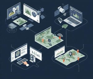
Remote Sensing: Satellites and aircraft use sensors to collect data from the earth’s surface, which provides pictures and details about the surrounding environment. These datas are crucial for monitoring changes inside the land usage, environmental conditions, and urbanization.
Geographic Information Systems (GIS): GIS are software tools that capture, store, examine, manipulate, manage and show all forms of geographic records. This allows visualization and analysis of spatial relationships, patterns and trends.
Global Positioning Systems (GPS): A satellite network orbits around the Earth equipped to receive specific data on the place, time, and velocity. GPS technology is critical to mapping, navigation, and location-based services.
Human Geography Analysis: This segment examines how human populations affect, and are influenced by geographical location. It analyzes patterns which can be related to one’s monetary activity, demographics and social behavior.
Geospatial Intelligence in Action
Geospatial Intelligence can be implemented to many industries, converting how businesses strategize and plan.
Software and Adtech
Software companies can leverage Geospatial Intelligence to revolutionize their offerings. Through integrating Geospatial intelligence into their technologies, they can personalize marketing strategies, optimize supply chain management and enhance Location based services. Software and Edtech businesses in association with GEOINT experts can leverage the ability in location data and AI technology and provide solutions that increase efficiency and improve competitiveness.
Retail and Marketing
Geospatial intelligence empowers retailers to make data-informed decisions about store locations, inventory management, and personalized marketing. By analyzing customer movement patterns, businesses can tailor their offerings to target specific demographics and meet local preferences.
With Google Maps Platform, retailers can leverage location intelligence to optimize store locations, enhance customer experiences, and boost marketing effectiveness through real-time geospatial insights.
Urban Planning and Development
The efficient usage of geospatial data in urban planning could result in stepped forward city layouts, advanced transportation systems, and improved service delivery. Planners use GEOINT to understand the density of population in addition to traffic patterns and anticipate the outcomes of new development projects.
National Security and Defense
GEOINT is vital in identifying feasible threats and assisting defense operations by supplying detailed maps and imagery. It aids in tracking the borders, tracking terrorist activity and assessing the outcomes of natural disasters for instant relief planning.
Disaster Management
In a world that is increasingly impacted through weather changes, geospatial intelligence assists understanding and managing natural disasters. It makes use of real-time imagery to track motion and plan recovery efforts using precise location data.
Key Applications of Geospatial Intelligence
Spatial Analysis
Spatial analysis is the examination of spatial relationships and patterns within data. By analyzing spatial data, organizations can spot trends, correlations and other anomalies that are not apparent by the use of conventional data analysis techniques.
Data Visualization
Data visualization is a powerful tool that converts complex geospatial data into a visible format that is easy to understand visuals, like graphs, maps, and charts. Effective data visualization improves communication and comprehension, permitting decision makers to grasp complex spatial data in a short time.
Predictive Modeling
Predictive modeling makes use of real-time and historic geospatial data to forecast the future of trends and events. Utilizing the strength of predictive modeling, corporations can prepare and expect various situations, like the occurrence of natural disasters and market fluctuations and population growth.
Risk Assessment
Risk Assessment is an important element of strategic decision making particularly in fields like insurance, finance as well as disaster management. Geospatial Intelligence enables organizations to assess the risk accurately by analyzing spatial information associated with environmental hazards, in addition to infrastructure vulnerability and demographic variables.
Resource Allocation
Efficient resource allocation is crucial for optimizing operations and maximizing the returns on investment. Geospatial intelligence gives valuable insight on resource utilization and distribution and helps companies allocate resources effectively.
Market Analysis
Market Analysis is examination of market trends, consumer behavior and competitive dynamics to formulate business strategies. Geospatial Intelligence improves market analysis by providing location-based insights which reveal spatial patterns and relationships.
Competitive Intelligence
Competitive intelligence includes collecting and studying facts regarding competitors to gain strategic advantage. Geospatial Intelligence helps to provide competitive intelligence by providing insights into market reach, competitors location and operational strategies.
Location-Based Insights
Location Based Insights are derived by analyzing geospatial data to determine the impact of location on various aspects of the business. These are essential in areas like retail as well as real estate and logistics, in which the location plays a pivotal role in success.
Decision Support Systems
Decision-support machines (DSS) are integrated tools that combine models, statistics, and analytical strategies to aid decision-makers in making choices based on information. Geospatial intelligence improves DSS by providing analytical abilities and spatial statistics which allow organizations to make data driven decisions.
Leveraging High-Accuracy Location Data
The precision of high accuracy location data allows organizations to understand consumer behavior, trends and traffic patterns. Based on these statistics, agencies are able to make significant operational improvements. In particular, Unacast technology ensures the privacy of each individual while providing an entire evaluation. Through aggregating, anonymizing and segmenting data. Unacast ensures compliance with GDPR as well as the strictest privacy policies.
The Future of Geospatial Intelligence
The future of geospatial intelligence is full of possibilities. Technology advancement as well as data collection and analysis are set to broaden the possibilities of what may be accomplished with location data
Advancements in AI and Machine Learning
AI and ML are transforming the field of geospatial intelligence by automating pattern identification, making predictions and data analysis. These technologies enhance the rate and accuracy in spatial analysis, this enables organizations to derive actionable insights from geospatial data.
Real-Time Spatial Analytics
The capability to analyze data in real time is becoming critical. In real time spatial analytics will permit immediate reaction to shifting market situations in addition to emerging threats and evolving consumer behaviors.
Continued Focus on Privacy
Data privacy importance will increase as regulations end up extra stringent and there may be heightened public awareness. Geospatial Intelligence solutions must continue to be at the forefront of privacy protection, and offer actionable data for his or her clients.
Conclusion
Geospatial Intelligence is an indispensable tool for any business that’s centered on data-driven strategic decision-making. Making use of the power of geospatial intelligence will not only improve operational efficiency but also help in a rapidly evolving landscape where data is the currency of innovation. Integrating Geospatial Intelligence in strategic decision making techniques can bring better outcomes across domains. By gaining a higher knowledge and leveraging the core components and applications of GEOINT, companies can stay ahead of the market and attain sustainable growth.
